What to See in Suchitoto, El Salvador: Free Audio Guide
Things to Do in Suchitoto, El Salvador
Looking for things to do in Suchitoto? This historic destination is known for its colonial past, its surrounding landscapes and its connection to some of El Salvador’s most important rivers and archaeological sites. Just outside town, you can explore Ciudad Vieja, the first location of San Salvador, while the countryside reveals streams, hills and the imposing Guazapa massif. Neywo offers a free audio guide for Suchitoto with 19 narrated places, available in 11 languages.
What to See in Suchitoto and Its Surroundings
Ciudad Vieja
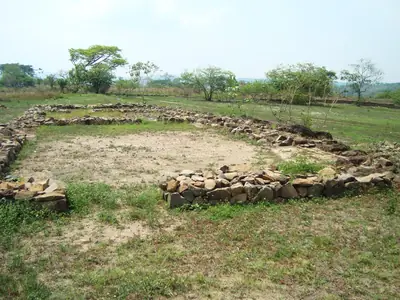
About ten kilometres south of Suchitoto, Ciudad Vieja preserves the first location of San Salvador. Spanish conquistadors founded a settlement here in 1525, but Indigenous resistance led them to abandon it three years later. The Spanish returned in 1528 and refounded the settlement in the Valle de la Bermuda.
Ciudad Vieja remained the administrative centre of the province until 1545, when San Salvador moved to the Valle de las Hamacas, where modern-day San Salvador developed. Because the settlement was abandoned rather than built over, its original sixteenth-century layout survived underground, making the site important for studying the Conquest era and the foundation of San Salvador.
Guazapa
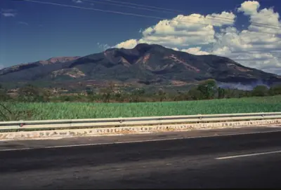
Guazapa dominates the horizon as a broad, rugged massif rising to 1,438 metres. It is an ancient Pleistocene basaltic stratovolcano whose original conical shape has been worn away by erosion. Deep valleys now cut through its flanks, and no crater remains at the summit. Whether the volcano could ever become active again remains debated by scientists.
Guazapa also carries the memory of El Salvador’s civil war in the 1980s. Its valleys served as a stronghold for FMLN guerrillas, who established camps, makeshift hospitals and bomb shelters among the natural fortifications. The mountains also contain clandestine cemeteries, reminders of the conflict’s human cost. Guazapa extends across the municipalities of San José Guayabal, Suchitoto and Guazapa.
Quebrada Las Barillas
Quebrada Las Barillas is a natural stream connected to the channel of the Río Lempa. Its waters pass through the landscape before joining El Salvador’s most important river system.
Quebrada Las Flores
Flowing through the Cuscatlán department, Quebrada Las Flores is a stream about thirty kilometres north of San Salvador. It is one of the waterways that characterise the rural landscape around Suchitoto.
Quebrada Las Lágrimas
Quebrada Las Lágrimas is a stream whose name translates as “Ravine of Tears.” Its simple course and evocative name add a small but distinctive detail to the waterways around the town.
Cerro El Coyote
Cerro El Coyote rises 450 metres above sea level among the farmlands of central El Salvador. It is a modest mountain rather than a high peak, but it forms a quiet presence in the Cuscatlán landscape.
Quebrada Las Lajas
Just outside Suchitoto, Quebrada Las Lajas cuts through the rolling hills of the Cuscatlán department. The stream belongs to the Río Lempa watershed, so its water eventually joins El Salvador’s largest river system.
Its character changes with the season. During the dry season, it may be little more than a gentle trickle; after the August rains, it can swell into a stronger torrent. The site lies roughly thirty kilometres north of San Salvador as the crow flies.
Quebrada Las Pacayas
Quebrada Las Pacayas flows through the central highlands of El Salvador, about twenty-nine kilometres north of San Salvador. Like several waterways in the area, it forms part of the landscape that feeds the Río Lempa system.
Río Agua Caliente
The Río Agua Caliente runs through the Cuscatlán department in central El Salvador. It belongs to the wider Río Lempa watershed, linking this local river to the country’s most important river system.
Río Asigüillo
The Río Asigüillo flows through the heart of the Cuscatlán department, about twenty-nine kilometres northeast of San Salvador. Its waters feed into the Río Lempa watershed.
Río Chalchigüe
The Río Chalchigüe is a river flowing through the heart of El Salvador’s Cuscatlán department. It is one of the waterways encountered in the countryside around Suchitoto.
Río Azambio
The Río Azambio is a tributary of the Río Lempa. Water from this quiet branch eventually joins the larger river, connecting the landscape around Suchitoto with the watershed that crosses much of El Salvador and drains into the Pacific.
Its flow varies with the weather. In the dry season it may be a gentle stream, while rainfall makes it run more strongly.
Río Concepción
The Río Concepción winds through the central Cuscatlán department, about thirty kilometres northeast of San Salvador. It forms part of the greater Río Lempa watershed and feeds into the country’s most important river as one of its tributaries.
Quebrada Las Cañas and Río Acelhuate
Quebrada Las Cañas flows through the Chalatenango department, about forty kilometres north of San Salvador, as a tributary of the Río Lempa. Further on, the Río Acelhuate also forms part of the Río Lempa system. Together, these waterways show how the streams and rivers of central El Salvador connect to the country’s principal river network.
Explore Suchitoto with Neywo
There are currently no walking, bus or bike routes listed for Suchitoto. Neywo’s free audio guide nevertheless includes 19 narrated places in the city and its surroundings, with narration in 11 languages.
Download Neywo and explore independently: the app tells the story of each place as you reach it, at your own pace, with no group and no schedule. You can also discover more of El Salvador or continue to San Salvador.
Places with an audio guide in Suchitoto
8 places in Suchitoto with a Neywo audio guide. Each one starts telling its story as you reach it.
Walk Suchitoto with Neywo
Neywo turns Suchitoto into a self-guided audio tour. Stories arrive as you reach the place they belong to, and the route reshapes when you wander off it.