What to See in Boquete, Panama: Free Audio Guide
Things to do in Boquete, Panama
Boquete is a mountain town in western Panama, known for its cool highland setting, forested slopes, rivers and views toward Volcán Barú. It is worth visiting for the chance to explore a landscape shaped by mountains, farmland and waterways rather than the tropical lowlands. Neywo offers a free audio guide for Boquete with 20 narrated places.
What to see in Boquete
The most memorable things to do in Boquete are found in the surrounding highlands. The landscape changes constantly, from the Caldera River running through town to forest-covered mountains and the distant summit of Volcán Barú.
Volcán Barú
The summit of Volcán Barú is the defining landmark of the region. At 3,475 metres, it is the highest mountain in Panama and an active stratovolcano. It is also the twelfth-highest peak in Central America. Located around 35 kilometres from the Costa Rican border, the volcano gives Boquete its dramatic mountain backdrop.
Volcán Barú also lies within the wider landscape of Volcán Barú National Park, connecting the town with high-altitude scenery and forested terrain.
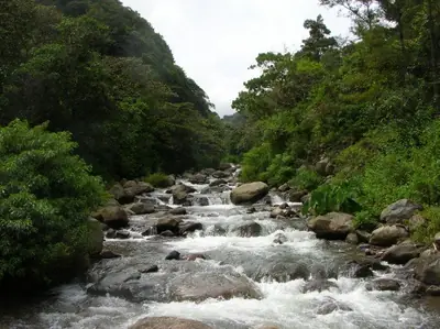
Caldera River
The Caldera River passes directly through Boquete before continuing through Volcán Barú National Park. It is an important natural link between the town and the surrounding mountains, and its waters have also shaped the area’s history.
In November 2008, the river overflowed its banks, causing extensive damage to infrastructure and leading to repairs on many roads. Today, it remains one of the clearest features of Boquete’s relationship with its natural surroundings.
Cerro Cabezón
A few kilometres from Boquete, Cerro Cabezón rises to 1,126 metres above sea level. Its forest-covered slopes and sparsely populated surroundings create a peaceful mountain setting, away from the busier parts of town.
Cerro Guacal
Cerro Guacal reaches 1,239 metres above sea level in Panama’s Chiriquí Province. Its forested surroundings offer another quiet view of the highlands, with Boquete located about 15.9 kilometres to the west.
Cerro Cuchilla and Cerro Grande
Cerro Cuchilla, at about 500 metres above sea level, offers a view of the lower, hillier landscape around Boquete. The area around it is more populated than some of the region’s higher mountain settings. Cerro Olga, the highest point in the wider area, reaches 2,201 metres and lies about 15 kilometres north of Cerro Cuchilla.
Nearby Cerro Grande rises to 606 metres, standing around 70 metres above the surrounding terrain. Its base covers roughly 0.84 square kilometres, forming part of the region’s open countryside and rolling landscape.
Cerro Azul
Cerro Azul rises to about 2,195 metres in Chiriquí Province and forms part of the Cordillera Los Andes. Its mostly forested setting shows how the landscape around Boquete shifts from rolling hills to more rugged mountain country.
The terrain to the southwest is formed by hills, while the northeast becomes more mountainous. A nearby high point reaches about 2,375 metres, around 2.1 kilometres northeast of Cerro Azul.
Cerro Guárico
Cerro Guárico is a 919-metre mountain surrounded by rolling terrain and open farmland. From here, Volcán Barú is the highest nearby point: it rises to 3,474 metres and lies about 16.6 kilometres to the northwest.
The contrast between farmland around Cerro Guárico and the higher volcanic landscape makes it a useful viewpoint for understanding the geography of the region.
Cerro Horqueta
Cerro Horqueta is a forested mountain reaching 1,894 metres in western Panama. Its proximity to Boquete—the town lies about 6.2 kilometres to the south—makes it part of the highland scenery most closely associated with the destination.
Cerro La Estrella and Cerro La Lata
Cerro La Estrella is surrounded largely by forest and offers a peaceful view of the highlands of Chiriquí Province. The surrounding terrain changes from hills to the southwest to more mountainous country toward the northeast. The highest nearby point reaches 2,295 metres, about 1.2 kilometres north of the mountain.
Further through the highlands, Cerro La Lata rises to 1,781 metres in a sparsely populated landscape. Forested slopes and changing terrain define the area, while a nearby point reaches 2,167 metres around one kilometre to the north.
Cerro Las Guacas
Cerro Las Guacas combines rolling hills, farmland and higher mountain country to the north. The land around the mountain is mostly hilly, with the terrain becoming more mountainous farther north. The highest nearby point reaches 935 metres and lies about one kilometre northwest of Cerro Las Guacas.
Cerro Guayabo Blanco
Cerro Guayabo Blanco is a forest-covered mountain rising to 1,473 metres. Much of the surrounding landscape remains wooded, and a nearby high point reaches 2,041 metres around three kilometres to the north.
Cerro Las Peñas
Cerro Las Peñas stands in a sparsely populated landscape where forested surroundings meet rolling hills and mountain terrain. Hills extend toward the southwest, while the land becomes more mountainous toward the northeast. Forest covers much of the area around the mountain.
Cerro Pianista
Cerro Pianista reaches 1,596 metres and stands in a landscape almost completely covered by forest. It is another example of the dense, mountainous setting that distinguishes Boquete from Panama’s lower and warmer regions.
Explore Boquete with Neywo
There are no scheduled group walks or fixed routes to join. Neywo’s free Boquete audio guide includes 20 narrated places, and each story plays as you reach the place, at your own pace, with no group and no schedule. Narration is available in 11 languages.
Download Neywo and explore Boquete independently: the app tells the story of each place when you arrive, so you can discover the town, the Caldera River and the surrounding mountain landscape on your own terms. When planning a wider trip through Panama, you can also explore destinations such as Panama City, Colón and El Valle de Antón.
Places with an audio guide in Boquete
8 places in Boquete with a Neywo audio guide. Each one starts telling its story as you reach it.
Walk Boquete with Neywo
Neywo turns Boquete into a self-guided audio tour. Stories arrive as you reach the place they belong to, and the route reshapes when you wander off it.