What to See in Glenwood Springs, United States: Free Audio Guide
Things to Do in Glenwood Springs, Colorado
The best things to do in Glenwood Springs include exploring historic buildings, following the Roaring Fork River, and discovering parks and open landscapes in the surrounding valley. The city combines a distinctive mountain setting with places that reveal its history, architecture, waterways, and local character. Neywo has a free audio guide for Glenwood Springs with 19 narrated places, available in 11 languages.
What to See in Glenwood Springs
Glenwood Springs is part of Colorado, in the western United States. Its sights range from historic landmarks in town to parks, waterways, and valley landscapes around Garfield County.
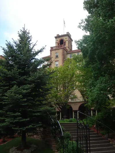
Hotel Colorado
Hotel Colorado is one of Glenwood Springs’ most recognizable historic buildings. Built in 1893, it is one of the oldest hotels in the state of Colorado. Its Italianate design is credited to architect Edward Lippincott Tilton, and the building has remained part of Glenwood Springs for generations.
The hotel is worth seeing for its architectural details as much as for its age. Its design gives the city a tangible connection to its past and makes it more than simply an old hotel.
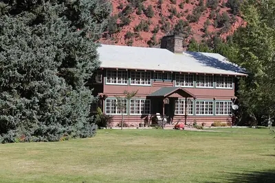
Sumers Lodge
Sumers Lodge brings a different architectural style to Glenwood Springs. This rustic, two-story log house has a substantial timber structure and a projecting sun porch on its entrance side. The simple design gives the building a distinctive mountain character.
Sumers Lodge was listed on the National Register of Historic Places in 1997, recognizing its importance as a historic building in Colorado.
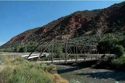
Roaring Fork River
The Roaring Fork River is one of the defining natural features of the Roaring Fork Valley. It flows for approximately 70 miles, or 110 kilometres, through Garfield, Pitkin, and Eagle counties before joining the Colorado River as one of its tributaries.
The river helps explain the shape and character of the surrounding landscape. Around Glenwood Springs, it is part of a wider valley setting of waterways, open ground, hills, and mountains.
Cascade Creek and Oasis Creek
Cascade Creek and Oasis Creek are smaller waterways in Garfield County. They form part of the local landscape and offer quieter natural features to notice while exploring beyond the city’s central buildings.
Rather than dramatic landmarks, these creeks show how water is woven through the valley around Glenwood Springs.
A E Axtell Park
A E Axtell Park is a quiet natural setting in a valley in Garfield County. The landscape opens into grassland, with hills to the south and mountains to the north. Waterways, canals, and flat areas are also part of the surrounding terrain.
The highest nearby point reaches about 2,412 metres and lies 2.1 kilometres east of the park, adding a sense of scale to this open valley setting.
Centennial Park
Centennial Park is another green space near Glenwood Springs, surrounded by a valley landscape. Rolling hills lie to the south, while mountains rise to the north. The surrounding terrain reaches toward a nearby high point of about 2,412 metres.
The park is a useful place to appreciate the contrast between open ground, nearby hills, and the mountain scenery around the valley.
Hyland Park
Hyland Park lies in a valley surrounded by rolling country to the south and mountains to the north. At an elevation of about 1,780 metres, it has a landscape largely covered by grassland.
Valleys, streams, and channels form part of the area around the park, creating a quiet natural setting close to Glenwood Springs.
Sister Lucy Downey Park
Sister Lucy Downey Park is set in a valley at an elevation of about 1,740 metres. Glenwood Springs is roughly 3.3 kilometres to the east.
Its position offers another perspective on the valley landscape around the city, where open spaces and mountain surroundings come together.
Two Rivers Park
Two Rivers Park is located in a valley in Garfield County, just a short distance from Glenwood Springs. Its peaceful setting makes it a natural place to pause while exploring the area.
The park belongs to the same wider landscape shaped by the valley and its waterways.
Atkinson Canal and Cemetery Gulch
Atkinson Canal is a local waterway in Garfield County, while Cemetery Gulch is a valley in the central part of the United States. Both are quieter features rather than major attractions, but they add detail to the landscape around Glenwood Springs.
Together with the creeks, parks, and rivers, they show the variety of natural forms found close to the city.
Citizens National Bank Building
At the corner of Grand Avenue and Eighth Street, the three-story Citizens National Bank Building stands out among the mostly one- and two-story buildings along Grand Avenue. It has been part of Glenwood Springs since 1913.
Denver architect Guy B. Robertson designed it as a two-part commercial block with Classical Revival ornamentation. Its flat roof, projecting cornice, and Chicago-style windows on the upper floors also reflect twentieth-century commercial architecture.
The building originally served financial businesses and later housed a specialty store and a hotel. It has also been known as the New Citizens Building. Its historic importance was recognized when it was listed on the National Register of Historic Places in 1999. The building is connected with Colorado Mountain College Central Services.
Colorado Mountain College
Colorado Mountain College is a public college headquartered in Glenwood Springs and serving communities across the Rocky Mountains. Founded in 1965, it offers associate degrees, eight bachelor’s degrees, and career and technical certificates.
The college has eight community campuses and three full-service residential campuses, including Spring Valley at Glenwood Springs. Its student life includes clubs, honor societies, a theatre company, sports teams, and recreational and educational activities.
Glenwood Airport
Glenwood Airport lies a few minutes from Glenwood Springs in a valley in Garfield County. At an elevation of 1,804 metres, it is surrounded by open grassland and hills, with mountains to the north.
The highest nearby point rises to 2,143 metres, about one kilometre northeast of the airport. The setting provides another example of the high-country terrain surrounding the city.
Explore Glenwood Springs with Neywo
There is no fixed group or timetable to follow. Neywo’s free audio guide includes 19 narrated places in Glenwood Springs, and each story plays as you reach the place, at your own pace. Narration is available in 11 languages, so you can explore independently while the app tells the story of each building, park, river, or other local feature as you arrive.
Download Neywo to discover Glenwood Springs with a self-guided audio guide: no group, no schedule, and no need to rush from one stop to the next. If you are continuing through the state, you can also explore Denver, Boulder, or Durango with the app.
Places with an audio guide in Glenwood Springs
8 places in Glenwood Springs with a Neywo audio guide. Each one starts telling its story as you reach it.
Walk Glenwood Springs with Neywo
Neywo turns Glenwood Springs into a self-guided audio tour. Stories arrive as you reach the place they belong to, and the route reshapes when you wander off it.