Kanab, United States: Self-Guided Walking Tour
Things to Do in Kanab, Utah
Looking for things to do in Kanab? This small town in southern Utah combines historic buildings, open desert landscapes and scenic routes through Kane County. Its streets and surroundings tell stories of changing travel routes, local hospitality and the dramatic terrain between Utah and Arizona. Neywo has a free audio guide for Kanab with 9 narrated places, available in 11 languages.
What to See in Kanab
The most interesting places to see in Kanab include historic buildings in town, distinctive natural features and roads that connect the surrounding landscape. Together, they offer a self-guided introduction to the area without reducing Kanab to a single viewpoint or attraction.
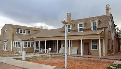
Kanab Lodge
Kanab Lodge began as a house built in 1885. Between 1928 and 1932, the Utah Parks Company expanded it into a rest stop for tourists travelling roughly halfway between the north rim of the Grand Canyon and Zion or Bryce Canyon National Parks.
The building now operates as the restaurant Jakes Chaparral, but its history includes several other names and uses: the Parry Cafeteria, the Utah Parks Building and the Wok Inn restaurant. Its changing identity reflects the different generations of travellers who have passed through Kanab.
Kanab Hotel and Cafe
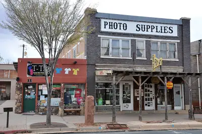
At 19 West Center Street, the Kanab Hotel and Cafe is a historic commercial building constructed in 1929. It was also known as Virge’s Kanab Hotel, Cafe and Bakery, linking the building to the town’s long tradition of hospitality and everyday commerce.
The building was listed on the National Register of Historic Places in 2003. Its brick, two-part commercial-block design includes a concrete foundation, a flat roof behind a cascading parapet and later one-story additions along the north and east sides.
Kanab Library
The Kanab Library offers another perspective on the town’s cultural history. A public library was first established here in 1915, while the present building was constructed in 1939 and 1940 as a Works Progress Administration project by Mark E. Pope.
Architect Carson Fordham Wells, Jr. designed it in a combination of Prairie School and Art Deco styles. The result is a distinctive civic building whose architecture reflects an important period in Kanab’s development.
Indian Dance Hall
Indian Dance Hall is a mountain in Kane County, with an elevation of 1,684 metres. Kanab lies about one kilometre to the west, while the nearby terrain rises toward Savage Point, whose elevation reaches 1,781 metres roughly 1.1 kilometres to the northeast.
The landscape changes around the mountain: the terrain is hilly to the northwest and flatter toward the southeast. That contrast makes Indian Dance Hall a useful place to observe the shape of the surrounding country.
U.S. Route 89A
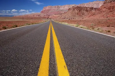
U.S. Route 89A connects Kanab with Bitter Springs in Arizona. Although it is officially designated as a north–south route, its course runs mostly east to west through southwestern Kane County and northeastern Coconino County.
The road follows an older alignment of U.S. Route 89 and extends for about 147.64 kilometres. It includes Navajo Bridge and provides the only direct road connection between the Arizona Strip and the rest of Arizona. The Utah section was signed as State Route 11 until 2008, adding another chapter to the road’s history.
Littles Campground and RV Park
A short distance from Kanab, Littles Campground and RV Park provides a place to stop in the open landscape of Kane County. The campground stands at an elevation of about 1,506 metres and offers a simple way to experience the area beyond the town itself.
Bunting Canyon
Bunting Canyon is a valley in Kane County. Its setting forms part of the wider landscape around Kanab, where open country and changing terrain extend well beyond the town’s streets.
Spencer Number Two Dam
Spencer Number Two Dam is a water-control structure beside Spencer Number Two Reservoir, about 3.8 kilometres south of Kanab. It stands at an elevation of approximately 1,480 metres in a quiet, sparsely populated landscape.
The surrounding area has a cool, dry climate, with average temperatures ranging from around zero degrees Celsius in December to thirty-three degrees in July. A nearby high point reaches 1,902 metres about five kilometres to the west.
Kanab Municipal Airport
Kanab Municipal Airport lies just south of the town, about two miles away. It is a general aviation facility owned by the city and is identified by the codes KNB for IATA, ICAO and FAA purposes.
The airport has a paved runway measuring 1,888 metres. Although it is not a sightseeing attraction in the usual sense, its location forms part of the infrastructure that connects Kanab with the wider region.
Exploring Kanab and Utah
Kanab is part of Utah, a state whose cities and landscapes offer very different ways to experience the American West. For a wider look at the country, see the United States destination page. Travellers continuing through Utah can also compare Kanab with Moab, Heber City or Park City.
Explore Kanab with Neywo
Neywo’s free Kanab audio guide covers 9 narrated places. Each story plays as you reach the place, at your own pace, with no group and no schedule. The narration is available in 11 languages, making it an easy way to turn a walk through Kanab into a self-guided discovery of its buildings, roads and surrounding landscape.
Places with an audio guide in Kanab
8 places in Kanab with a Neywo audio guide. Each one starts telling its story as you reach it.
Walk Kanab with Neywo
Neywo turns Kanab into a self-guided audio tour. Stories arrive as you reach the place they belong to, and the route reshapes when you wander off it.