Visiting Puerto Peñasco, Mexico: Top Sights on Foot
Things to Do in Puerto Peñasco: Desert Landscapes and the Sea of Cortez
Puerto Peñasco is a coastal city in northwestern Sonora, Mexico, known for its extensive beaches along the Gulf of California and its dramatic desert surroundings. From volcanic peaks and isolated hills to baseball, a lighthouse, and a nearly dry desert river, the city offers more to discover than its shoreline alone. Neywo has a free audio guide for Puerto Peñasco with 20 narrated places, available in 11 languages.
What to See in Puerto Peñasco
The most interesting places to visit around Puerto Peñasco reveal the meeting point between the Sonoran Desert and the Sea of Cortez. The following landmarks are best understood as part of the city’s wider landscape.
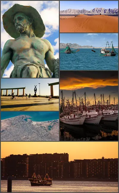
Puerto Peñasco and its coastal setting
Puerto Peñasco’s modern history is closely connected to its coast. The shoreline was discovered in 1826, while permanent settlement began much later, when fishermen established themselves here in the 1920s. The city expanded during the 1930s and 1940s, after a railway was built and migrants arrived to work on it.
The city is also called Rocky Point, and sometimes the Beach of Arizona. These names reflect its close connection with visitors from the United States. Its beaches stretch along the Gulf of California, making Puerto Peñasco one of northern Mexico’s important tourist destinations.
Pinacate Peaks
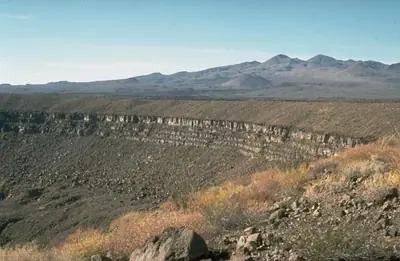
The Pinacate Peaks, or Sierra del Pinacate, rise from the Sonoran Desert beside the international border and the state of Arizona. This volcanic mountain group includes mountains, craters, and volcanic cones, surrounded by the sand-dune field of the Gran Desierto de Altar.
The area also has a recorded history of exploration. Father Eusebio Kino explored the Pinacate Peaks in 1698 after founding Spanish missions in the Sonoran Desert. The combination of volcanic terrain and vast desert makes this one of the region’s most distinctive natural landscapes.
La Ballena Hill
La Ballena Hill is one of Puerto Peñasco’s defining landmarks. The rocky hill stands beside the Sea of Cortez and provides a natural viewpoint over the beaches, hotel district, tourist area, malecón, and sea horizon. It is the highest point in the city and is used locally as a lookout.
The hill formed during the Quaternary period, when lava solidified after coming into contact with seawater. A lighthouse rises from the hill, reaching 110 metres and serving as a guide for boats at sea. The reason for the name La Ballena, meaning “the whale,” is not known among local residents.
Cerro Crestón Colorado
Cerro Crestón Colorado is a mountain in the municipality of Puerto Peñasco. It rises to 134 metres above sea level and stands out where the surrounding terrain changes from flat land to hills. It is a useful landmark for appreciating the gradual shift between the open desert and the region’s elevated terrain.
Cerro Chijubabi
Cerro Chijubabi reaches 423 metres above sea level in a sparsely populated part of Sonora. The land around it is generally flat, while hills rise to the west. The highest nearby point reaches 1,017 metres and lies 12.1 kilometres to the northeast.
Cerro El Chivo
Cerro El Chivo rises above the open landscape of Puerto Peñasco. The hill reaches 325 metres above sea level and stands about 89 metres above the surrounding ground. Its base is approximately 0.89 kilometres across, giving it a broad presence in an otherwise sparsely populated setting.
Cerro La Choya
Cerro La Choya is a low hill beyond Puerto Peñasco, surrounded by the broad, flat landscape of Sonora. Its open surroundings make it a simple but effective place to appreciate the area’s dry character and wide horizons. The sea is the closest major feature to the southwest.
Cerro La Cueva
Cerro La Cueva is a mountain rising above mostly flat surroundings. It reaches 144 metres above sea level and stands about 55 metres above the terrain around it. Its base is approximately one and a half kilometres across, making it a clearly visible natural landmark in the open landscape.
Cerro La Silla
Cerro La Silla means “Saddle Hill”, a name that reflects the mountain’s distinctive isolated form. It rises from the mostly flat landscape of Puerto Peñasco to 464 metres above sea level, or about 225 metres above the surrounding terrain.
Its base extends roughly 7.4 kilometres across, giving the mountain a broad presence despite the openness of the desert around it.
Cerro Picu
Cerro Picu is a prominent hill within the municipality. It reaches 335 metres above sea level and rises about 120 metres above the land around its base. The hill is roughly 2.6 kilometres across at its foot, creating a substantial change in the surrounding desert landscape.
Cerro Prieto
Cerro Prieto stands 115 metres above sea level, or about 110 metres above the surrounding terrain. Its base extends for roughly 2.1 kilometres, making it a distinctive point of reference in the broad, mostly flat desert.
Sonoyta River
The Sonoyta River crosses the borderlands of Sonora and Arizona before reaching the Gulf of California near Estero La Pinta, about 20 kilometres east of Puerto Peñasco. It is unusual because it is almost always dry: water generally flows through its channel after rain in the surrounding desert.
The river’s channels and washes contain gravel, sand, silt, and clay. Smaller streams in the basin are usually temporary, carrying water in sudden flows after storms. The river begins in Arizona, enters Sonora, passes near several mountain ranges, and eventually turns south toward the gulf.
Bahía de San Jorge
Bahía de San Jorge is a bight on the coast of Sonora. Its dry coastal setting offers another view of the landscape that defines this part of northwestern Mexico, where desert terrain meets the Gulf of California.
Francisco León García Stadium
Francisco León García Stadium is a baseball venue at the heart of Puerto Peñasco’s La Milla sports circuit, the city’s most important sports circuit. It is home to the Puerto Peñasco Tiburones.
The stadium opened in 1967 and underwent a major renovation for the 2017 season. The work added a new left-field section, an electronic scoreboard, upgraded restrooms and changing rooms, synthetic turf, a roof, lighting, and a new façade. A restaurant-bar was also added to the central area. Although baseball is its main purpose, the stadium has also hosted music and religious events, including performances by Tercer Cielo, Banda el Recodo, Funky, and Laberinto.
Explore Puerto Peñasco with Neywo
Neywo’s free Puerto Peñasco audio guide includes 20 narrated places. The app tells the story of each place as you reach it, at your own pace, with no group and no schedule. Narration is available in 11 languages.
Download Neywo and explore Puerto Peñasco independently, moving from the city’s coastal landmarks to its volcanic mountains, desert hills, river channels, and local sports venues. If you are planning a wider trip through Mexico, you can also continue discovering destinations such as Oaxaca, Sayulita, or San Cristobal de las Casas.
Places with an audio guide in Puerto Peñasco
8 places in Puerto Peñasco with a Neywo audio guide. Each one starts telling its story as you reach it.
Walk Puerto Peñasco with Neywo
Neywo turns Puerto Peñasco into a self-guided audio tour. Stories arrive as you reach the place they belong to, and the route reshapes when you wander off it.